|
Auktionshaus Kiefer
Steubenstraße 36
75172 Pforzheim
Telefon 07231 / 92 32 0
http://www.kiefer.de
neue Website >>
Testen und nutzen Sie unsere kommende Website. || Test and use our new upcoming website.
Auction 144:
Translator:
Auction 123
Context information


|
|
Search items
facebook
Kiefer.de - Newsletter
|
You are actually browsing a previous auction.
Items shown are not availble to buy or to place a bid.
123-2905 Leicestershire.
A new map of Leicestershire, divided into hundreds. Exhibiting its roads, rivers, parks, etc. Kolor. gest. Karte bei J. Cary, London 1801. In 15 Segmenten auf Lwd. aufkasch., mehrf. gefalt. 56 x 50 cm. - Tls. schwach wasserrandig, ob. Rand tls. beschabt, Bugfalz tls. mit kl. Loch.

|
Next auction 144 takes place in July 8-10, 2026
NEW:
KIEFER Pforzheim
Tel. +49 (0)7231 / 9232-0
Similar items

144-3052 Lafréri, Antonio, 270,00 €
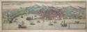
144-3046 Genua., 120,00 €

144-3039 London., 100,00 €
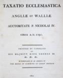
144-2121 Taxatio Ecclesiastica, 150,00 €

144-2123 Wirth,L.P., 100,00 €
|
|
|